
Pearland, Texas — The Complete Community Guide for Relocating Families
Pearland, Texas — The Complete Community Guide for Relocating Families By Crystal Plummer Spruill | TheHoustonReloGuide.com Last Updated: August 2026
The Quick Version
Pearland is a city of roughly 130,000 residents spanning Brazoria, Fort Bend, and Harris counties, just south of Houston along State Highway 288. It’s one of the closest suburban communities to the Texas Medical Center — a genuine draw for healthcare professionals — and it’s matured past its “fastest-growing suburb” reputation into a full-sized city with real retail, dining, and community infrastructure of its own. It also has a name with a genuinely surprising backstory.
This guide covers the neighborhoods, the commute math, and the real history behind the pear on every city sign.
What Is Pearland?
Pearland started life in 1882 as a siding switch on the Gulf, Colorado and Santa Fe Railway. When a post office was established in 1893, the community was actually named Mark Belt — the “Pearland” name only arrived the following year, chosen because of the sheer number of pear trees growing in the area. Ironically, most of those original pear trees were destroyed by hurricanes in 1900 and 1915, meaning the city has carried the pear as its identity — its sculptures, its murals, its seal — for well over a century after most of the actual pear trees were gone. Oil and gas discoveries in 1934 (the Hastings Oilfield) helped revive the local economy, and explosive growth followed starting in the 1970s.
That growth has genuinely slowed in recent years — Pearland’s population growth rate has settled to under 1% annually, a far cry from the double-digit annual growth of the 1960s. It’s no longer a boomtown; it’s a mature, established city of roughly 130,000 people.
Geographic Coverage
Pearland is unusual among Houston suburbs in spanning three counties: most of the city sits in Brazoria County, with sections extending into Fort Bend and Harris counties. As with every suburb in this guide series, the specific county your address falls in affects your property tax structure — verify before you buy.
The Neighborhoods
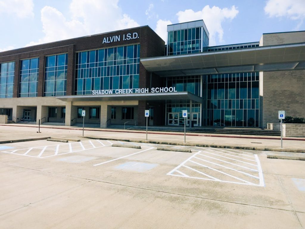
Shadow Creek Ranch Pearland’s largest and most recognized master-planned community, at 3,500 acres, and consistently ranked among the top master-planned communities in the Houston region. It’s genuinely diverse — more than 40 languages are spoken among families in its schools. Important to know: the majority of Shadow Creek Ranch (the Brazoria County portion) is zoned to Alvin ISD, including Shadow Creek High School itself, while a smaller section (the Fort Bend County portion) is zoned to Fort Bend ISD instead — either way, not Pearland ISD. See our Pearland ISD guide for the full boundary breakdown on this. Amenities lean resort-style, with extensive trails, multiple pools, and its own nature park.
Silverlake Developed in 1995 as the first large-scale master-planned community along Highway 288, anchored by a golf course and a private lake. It sold so well that within two years it became the second-highest-selling housing development in the Houston area at the time. Homes here run from the 1990s and early 2000s, generally zoned to Pearland ISD.
Southwyck An established, quieter community organized around a golf club and lake park, generally attracting buyers — including empty nesters and retirees — who want more space and a slower pace than Shadow Creek Ranch’s newer, more amenity-dense feel.
Meridiana Currently the standout for new construction and resort-style amenities in the broader Pearland area — worth verifying the exact address and district, since some newer communities carrying a Pearland identity sit outside Pearland ISD or even outside city limits.
Regency Park and Heritage Green More affordable, centrally located options, generally in the mid-$200,000s to mid-$300,000s, close to everyday retail like Kroger and ALDI.
Kelsey Pointe, Creekside, and Canterbury Park Pearland’s northernmost neighborhoods, sitting closest to the Harris County line — these offer the shortest commutes into the Texas Medical Center and downtown Houston of any part of the city.
Old Townsite The historic core of Pearland — where the city was actually born as that 1882 railway siding — now home to local boutiques and specialty shops along the Broadway corridor, a genuinely different feel from the master-planned communities that now surround it.
Cost of Living
Home prices vary significantly by neighborhood — Regency Park and Heritage Green run mid-$200,000s to mid-$300,000s, Southwyck runs high-$200,000s to low-$400,000s, and Shadow Creek Ranch sections like Reflection Pointe and Heron Bay run mid-$300,000s to over $500,000. Median household income sits around $118,800, above both the Texas and national averages.
One cost that catches out-of-state buyers specifically: Brazoria County — where most of Pearland sits — is one of Texas’s 14 officially designated coastal catastrophe counties for windstorm insurance. No Texas county legally mandates windstorm coverage, but in practice, standard homeowners policies in these designated coastal counties typically exclude wind and hail damage entirely. That means most Brazoria County homeowners in Pearland need either a private windstorm policy or coverage through the Texas Windstorm Insurance Association (TWIA), the state’s insurer of last resort — and mortgage lenders generally won’t finance a home without it. This is a real, ongoing cost to budget for, separate from your regular homeowners premium. It does not apply to the Fort Bend or Harris County portions of Pearland, which fall outside the designated catastrophe area.
Commute
This is genuinely one of Pearland’s strongest selling points: State Highway 288 provides one of the most direct suburb-to-hospital-campus commutes in the Houston area, putting the Texas Medical Center roughly 20–28 minutes away off-peak, or 28–40 minutes during AM rush hour. Toll lanes on SH 288 have further cut peak commute times. Beltway 8 provides east-west access to League City, Hobby Airport, and Pasadena without needing to go through downtown at all. This commute profile is a major reason Pearland has historically attracted healthcare professionals specifically.
Schools
Pearland is served by both Pearland ISD and Alvin ISD depending on the specific neighborhood — we cover this district-by-district, campus-by-campus, in our full Pearland ISD guide, including exactly which popular neighborhoods (like Shadow Creek Ranch) carry a Pearland identity but are actually zoned to Alvin ISD. Never assume district based on the city name alone — verify the specific address.
Lifestyle & Amenities
Pearland’s identity runs deeper than its shopping centers, though it has those too — Pearland Town Center anchors much of the city’s retail and dining. The Pear-Scape Art Trail is the public art series behind those pear sculptures and murals around the city — a genuine, intentional piece of civic identity building on the town’s actual namesake.
Pearland sits directly in the North American Central Flyway, making it a genuinely notable birdwatching destination — the Shadow Creek Ranch Nature Trail includes paved paths and an observation deck for viewing species like Sandhill Cranes and Red-Shouldered Hawks.
The Sri Meenakshi Temple, one of the most significant Hindu temples in the region, is located in Pearland and is a real part of the city’s cultural landscape — reflecting the genuine diversity found throughout Pearland’s neighborhoods and schools.
Healthcare
Pearland has real, substantial healthcare infrastructure of its own, which lines up directly with its Medical Center commute advantage. HCA Houston Healthcare Pearland provides a full-service hospital within the Shadow Creek Ranch area. Memorial Hermann Pearland Hospital and facilities from Houston Methodist also serve the city. Kelsey-Seybold Clinic — a major Houston-area healthcare system — is headquartered in Pearland and operates a large clinic campus here, not just a satellite location.
Growth
Pearland’s population is projected around 130,000 in 2026, making it roughly the 30th-largest city in Texas. But the growth rate itself has genuinely slowed — down to under 1% annually, compared to double-digit annual growth in the 1960s and still-strong growth through the 2000s. Pearland today reads less like a boomtown and more like a mature, fully built-out city with the retail, dining, and civic infrastructure to match — a meaningfully different growth story than still-expanding suburbs further west like Katy.
What Relocating Families Need to Know
- Not every Pearland-identified neighborhood is zoned to Pearland ISD. Shadow Creek Ranch, the city’s largest and most recognized community, splits between Alvin ISD (most of it) and Fort Bend ISD (a smaller section) — never Pearland ISD. See our Pearland ISD guide for the full breakdown.
- If your address is in the Brazoria County portion of Pearland, budget for windstorm insurance. Standard homeowners policies typically exclude wind and hail coverage in this designated coastal catastrophe county, meaning most buyers need a separate windstorm policy or TWIA coverage — and mortgage lenders will require it. This doesn’t apply to the Fort Bend or Harris County sections of the city.
- Flooding varies significantly by area. The northern Harris County section of Pearland has a different drainage history than the Brazoria County south, and has experienced more flooding issues. Shadow Creek Ranch and Silverlake generally have decent flood records, but individual property history still matters — always pull the FEMA flood map and seller’s disclosure for a specific parcel.
- The Medical Center commute is a genuine, distinctive advantage — one of the most direct suburb-to-TMC drives in the Houston area, which is why Pearland has historically drawn healthcare professionals specifically.
- Pearland’s “fastest-growing suburb” reputation is outdated. Growth has slowed considerably; this is now a mature, established city rather than a boomtown.
Is Pearland Right for You?
That depends on what you’re prioritizing — Pearland offers a genuinely strong Medical Center commute, real cultural diversity, and established city infrastructure, but flood history and school district both vary significantly by exact neighborhood. This guide is a starting point for your own research, not a recommendation of one community over another.
Resources
- Pearland ISD Find My School / zoning information: pearlandisd.org
- Alvin ISD zoning information: alvinisd.net
- Brazoria County Appraisal District: brazoriacad.org
- Fort Bend County Appraisal District: fbcad.org
- FEMA Flood Map Service Center: msc.fema.gov
Ready to Find Your Pearland Address?
Understanding the city is the first step. Confirming that a specific home sits in the right school district, the right flood zone, and fits your actual commute is the next one.
Book a Free Relo Connect →
Or use the Houston Neighborhood Navigator to get your top three suburb matches based on your employer corridor, your family’s priorities, and what the market actually looks like right now.
[Find Your Suburb →]
This guide is provided for informational purposes only and reflects publicly available data as of August 2026. Home prices, flood zone designations, and school zoning change regularly and vary by exact address. Always verify current information directly with Pearland ISD, Alvin ISD, the relevant county appraisal district, and FEMA before making any real estate decision. Crystal Plummer Spruill is a licensed Texas REALTOR® brokered by Real Broker LLC (TREC #0688471). Nothing in this guide constitutes a recommendation of one community over another.
Sources: Texas State Historical Association (TSHA), Texas Senate Resolution 213 (2023), U.S. Census Bureau, World Population Review, Pearland Economic Development Corporation, City of Pearland, Homes.com, Texas Ally, Lisa Marie Sanders Real Estate, Jeff Bulman Real Estate.
FAQ
Why is it called Pearland? The community was originally named Mark Belt when a post office opened in 1893. It was renamed Pearland the following year because of the abundance of pear trees in the area — though most of those original trees were later destroyed by hurricanes in 1900 and 1915.
Is Shadow Creek Ranch in Pearland ISD? No — despite being Pearland’s largest and most recognized neighborhood, Shadow Creek Ranch splits between two other districts: the majority (Brazoria County) is zoned to Alvin ISD, and a smaller section (Fort Bend County) is zoned to Fort Bend ISD. See our full Pearland ISD guide for the details on this and other boundary surprises.
What’s the commute like from Pearland to the Texas Medical Center? Genuinely one of the best in the Houston area for this price range — roughly 20–28 minutes off-peak via State Highway 288, or 28–40 minutes during AM rush hour.
Does Pearland flood? Parts of it do, particularly the northern Harris County section, which has different drainage characteristics than the Brazoria County portion of the city. Always check the FEMA flood map and a home’s specific flood history rather than assuming based on the city overall.
Do I need windstorm insurance in Pearland? It depends on which county your address falls in. Brazoria County — where most of Pearland sits — is a designated Texas coastal catastrophe county, meaning standard homeowners policies typically exclude wind and hail coverage there, so you’ll need a separate windstorm policy or TWIA coverage. This does not apply to the Fort Bend or Harris County portions of the city.
Is Pearland still one of the fastest-growing suburbs in Houston? Not anymore — growth has slowed to under 1% annually. Pearland has matured into an established city with its own retail, dining, and healthcare infrastructure, rather than a rapidly expanding boomtown.